Are you planning a photoshoot at an unknown location? Or maybe you’re an engineer who constantly needs to make the land measurements? Or are you planning to build a house and you’re looking for a reliable tool to survey the land?
You may also like: 11 Best Land Surveying Software for PC
Whichever purpose you have, there are great apps for your smartphone that can assist you with that without the necessity to use any additional equipment. Check out the article down below and see which one you like the most.
1. GPS Fields Area Measure
GPS Fields Area Measure is one of the best apps in this category. You will be able to calculate all the necessary data without much effort. The app interface is well thought out. In the menu, you can find hints with labels. The graphics are also well-drawn and it will be easier for you to understand the terrain.
Another nice bonus is that the app is free.

Distinctive features of the app:
- You have the ability to use the app even if you do not have access to the Internet. You can mark all the necessary data and save the information.
- You can always contact your colleagues and send them the data in the appropriate formats .kml .kmz or Esri.
- You can create separate folders, then sort your content to make it easier for you to find information.
- With this application, you will be able to save your money, as you will not need to buy special equipment.
The rating of the app is quite high and is 4.8. Many users note that they like the app and its functionality. They write that the application interface is well thought out even for beginners.
Some users have encountered problems when uploading files, but the developers actively monitor this and respond to almost every user, trying to quickly fix all technical problems.
Key Features:
- User-friendly interface
- High rate
- Access to the app without the Internet

You may also like: 10 Best Games Like Terraria for Android & iOS
2. Land Calculator: Survey Area, Perimeter, Distance
Land Calculator is another great app for measuring the earth. This app is often used by students, farmers, and even engineers. The app interface is designed in a convenient format; there are inscriptions with explanations and hints everywhere. The app’s graphics are similar to regular maps.

Distinctive features of the app:
- You can find out the size of an area of land of any size just by walking or driving around its perimeter with this app.
- You can draw a plot on the map in the app, and then the app will automatically tell you the area and size of this plot.
- If you need to measure the distance from point A to point B, you can also do this in the app.
- In the app, you can find different coordinate systems.
- If you are afraid that your data may be erased, then you can configure the backup function.
- Here you can also upload files in the appropriate formats or format them to the desired formats.
The app was installed by more than a hundred thousand people. It is actively used by real estate agents, as well as insurance agents. Many users note that the application is easy to use, but has all the necessary tools for accurate calculations.
Some users had technical problems, but the developers regularly release updates in order not only to fix technical bugs, but also to add new features.
Key Features:
- User-friendly interface
- Distance from point A to point B
- Regular new features
3. Planimeter GPS Area Measure
The following application from the developer VisTech is presented in the App Store. With this app, you will be able to measure the area of the earth using the GPS function. The application can be used by both amateurs and professionals in their fields.
The application interface is well thought out. In the menu, you can find hints with labels. The graphics are also well drawn and it will be easier for you to understand the terrain.

Distinctive features of the app:
- The app allows you to accurately measure the area and distance.
- You can measure sections in the units you need, such as kilometers, yards, and so on.
- You can share data directly from the app by sending it to other people in messengers or by email.
- You can also upload files or import them in the appropriate formats.
- The app has a zoom function, which makes the measurements even more accurate and the measurement process easier.
- If you have access to GPS on your phone, the app will be able to give you the location coordinates.
- The scope of the application is quite wide, ranging from measurements when playing golf, ending with the construction of plots.
The rating of the app is quite good and is 4.2. Many users note that this is a great app for asphalt estimation.
However, some users want to see the following improvements: It wouldn’t be much easier and more accurate for the work if people could zoom in further on the satellite image. It’s fine if it’s pixelated, people need more accurate points.
The pins need to be either translucent or simply small dots. The pins coming off the map effect covers up the image where people need to place the next point in some cases thus causing loss of accuracy. The developers promise that they will take into account and try to make changes.
Key Features:
- User-friendly interface
- High rate
- Variety of functions

4. Geo Measure Area Calculator
The next earth measurement app is Geo Measure Area Calculator from developer Bhavin Machchhar. This application is free, but it has good functionality.
The application’s user interface is well-designed. Hints with labels can be found in the menu. The images are very well-drawn, making it easy to comprehend the terrain.
Distinctive features of the app:
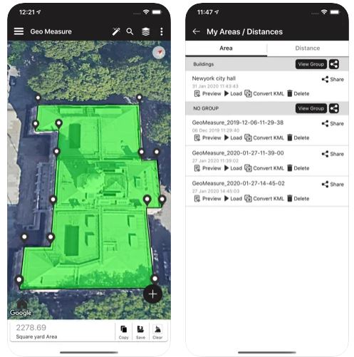
- You can measure the territory manually, just set point A and point B in the app with a few clicks.
- You can use the GPS function and measure the distance automatically, that is, the app will do everything for you, isn’t it cool?
Who is this app intended for?
To be honest, this app may be needed by almost every user; you don’t necessarily need to be an engineer. If you are a gardener and you need to measure the area of your plot, you can use the application, or, for example, if you want to build a fence around your house, then you will also need this application.
Users say that they like the app, especially the fact that you can use it for free. You can understand the interface in a few minutes. In order to measure areas, the application has all the necessary functions.
Key Features:
- User-friendly interface
- High rate
- Free app
5. Theodolite
The following Theodolite application combines several functions at once, such as: navigation calculator, compass, GPS, and so on. The app was first released back in 2009 and it was one of the first apps in this field.
It may not be easy to understand the interface right away, since there are really a lot of different functions, but after spending a little time, you will be pleasantly shocked by such a powerful tool that will come in handy in your work.

In addition to the fact that the app has basic tools for measuring territories, there are also other features:
- You can leave various comments or notes inside the app, to individual points or sections, and then share the information with other people.
- Another feature is that the app has a zoom function.
- You can determine your location, but here you will see parks, buildings, sculptures, attractions, and so on the map.
- The developers have thought through the application so much that you can view the probability of fires in the selected area.
- Here you can also choose a coordinate system that is convenient for you.
- You can import and send files in the appropriate formats.

The rating of the application is quite good and is 4.7. Many users really like such a wide functionality. Many note that this is the best app they have used.
One example of a user is that he recently used it to find a forest fire that had gotten within 3.1 miles of him. He took photographs at various places in the burnt area and then plotted the location on a Quadrangle map. This allowed us to quickly navigate in such a situation.
Key Features:
- Individual sections
- High rate
- Send and export files
You may also like: 11 Best Base Building Games for Android & iOS
6. Simple GPS Survey
This application has basic functionality and is suitable for recording coordinates. If you allow tracking your location on the device, the app will automatically show you the latitude and longitude of your location.
The interface is designed for each user and you can easily understand it, especially since there are many tables with labels and hints. The graphics are designed using bright colors.
Distinctive features of the app:

- You can collect all the information about the location and coordinates with a few clicks, and the app will automatically generate the information in a table.
- If you need to make changes manually, you can also edit your notes.
- All your changes that you make are saved automatically and you can continue working on them later.
User reviews are mixed, so the rating of the app is 3.6. Some people write that they do not have difficulties when using it and everything is intuitive.
However, many users report technical problems, after which they do not want to use the application. Developers try to respond quickly to users and fix bugs.
Key Features:
- User-friendly interface
- High rate
- Basic functions
7. Map Pad GPS Land Surveys & Measurements
With the Map Pad GPS Land Surveys & Measurements app, you can measure areas, collect data about them, and share information with colleagues.
In the application, you can find quite a lot more menus and to understand it, you will need some time. The graphics are almost identical to the rest of the applications.

Distinctive features of the app:
- One of the nice bonuses is that you can monitor the changes of any object in real-time.
- You do not need to measure the perimeter of the area of the site yourself, using expensive equipment. You can simply open the maps and specify the distance between the points and the app will calculate everything for you, thereby saving you money.
- You will definitely need this application if you want to build a house, or, for example, create your own garden or cottage. The app will also be useful for architects and realtors.
In general, the rating of the application is good and is 4.0. Many users note that such an application saves a lot of time and money. People write that the app is much more convenient to think through maps than in other similar apps.
Key Features:
- User-friendly interface
- Save money and time
- Share information with others
8. Surveying In the Field
If you work as a surveyor or are closely associated with this field, then the Surveying In the Field app will definitely be a good helper for you. You can find it in the PlayMarket based on Android.
The interface of the app is very simple and you will be able to understand it from the first minutes of using the app. The graphics of the application are designed in a minimalistic style and it will not distract you from your work, and you do not need to strain your eyes.

Distinctive features of the app:
- In this app, you can explore and follow the selected territory in real-time.
- The app has all the basic functions for measuring territories.
- Another nice bonus is that the app is free. This application is included in the TOP 10 applications for measuring territories.
The rating of the application is quite good and is 4.3. Many users note that the application is really easy to use, and the visual component does not distract from the workflow.
Key Features:
- User-friendly interface
- High rate
- Follow the territory in real-time
9. Survey Master
The next application for measuring the area of territories is Survey Master. You can find it in the PlayMarket based on Android.
The interface is designed in such a way that each user can quickly figure out how to use the application. The graphics themselves are mostly decorated in white and blue colors, which allow you not to be distracted from the workflow.

Here you can also specify the distance from point A to point B, swap them, add new points, and learn the distances. You can also upload and send files in the appropriate formats, such as TXT, CSV, and AutoCAD DXF. Another nice bonus is that you can use the app for free.
You need to remember that in order to use this app, you will need to enable Bluetooth on your device.
The rating of the application is quite good and is 4.2. Many users like that there is nothing superfluous in the application, as well as the fact that they do not need to spend a lot of time to understand the interface and functionality.
Some users had technical problems, but the developers try to quickly fix the problems.
Key Features:
- User-friendly interface
- High rate
- Basic functions
10. Property Survey GPS
The next application that you can use to measure land plots is Property Survey GPS. The application interface is designed for each user. You will also be able to find hints inside the app. The graphics are generally designed in the classic style of similar applications.
Distinctive features of the app:

- Even if you don’t have access to the Internet, you can still use the app. You can mark all of the necessary information and save it.
- You can always get in touch with your colleagues and send them the information in the appropriate formats.
- You can make different folders, and then organize your content to make it easier for you to find information.
- You will be able to save money by using this application because you will not need to purchase any special equipment.
Despite the basic functionality and the usual graphics, the app has a lot of negative reviews. People write that they constantly have technical problems.
Key Features:
- User-friendly interface
- High rate
- Make different folders
You may also like: 11 Best Measure Distance Software for PC, Android, iOS
11. Super GeoGPS
Our latest app on this list, but not the last rated one, is Super GeoGPS. You can find it in the PlayMarket based on Android.
The application interface is designed specifically for different levels of users. You will definitely be pleasantly surprised by the graphics because it is presented in a bright style and is close to the real style.

Distinctive features of the application:
- In this app, you can use seven parameters to measure the distance.
- You can also use different coordinate systems. You can add various comments or notes to individual points or sections within the app, and then share the information with others.
- You can choose your location, but you’ll see parks, buildings, sculptures, and other points of interest on the map.
In general, the app has a good rating and it is 4.3. Many people like the clear interface and beautiful graphics. Users also note good performance and wide functionality.
Key Features:
- User-friendly interface
- High rate
- Add comments to projects
Thus, in this list, we have collected the best Land Surveying Apps for Android and iOS. Each app has its own distinctive features.
Many apps contain similar functionality with some particular options, despite the fact that they are the entire same genre. We are sure that every user will be able to find something suitable for themselves.